 |
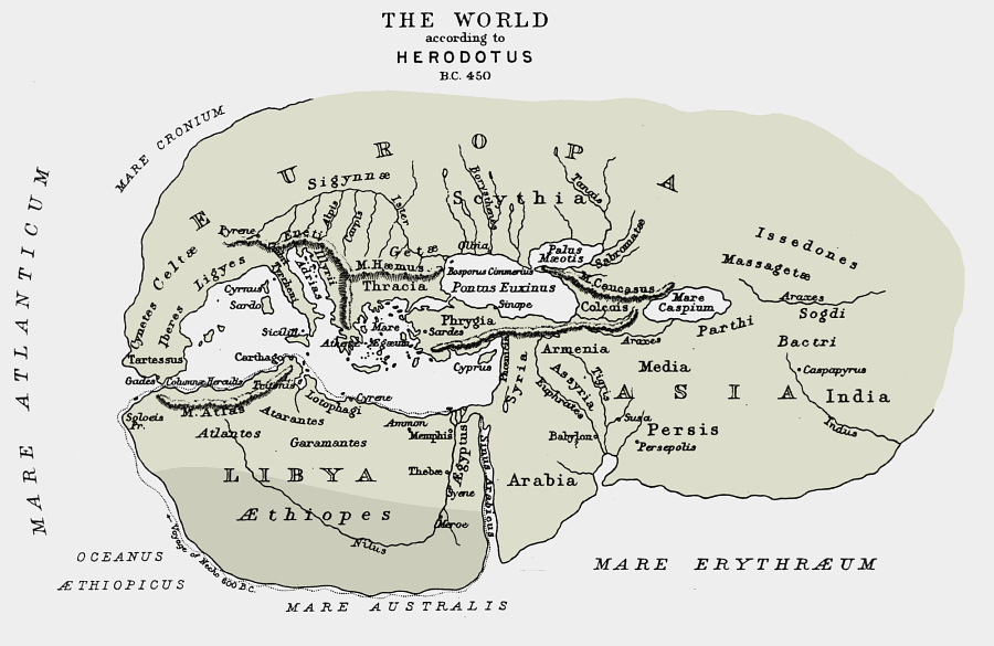
| Map of the world according to Herodotus - 450 BC |
Herodotus the Greek cartographer drew the map of the known world in his time quite accurately, as far as of places that were then familiar to mankind.
Some prominent features on the map are:
Land of Israel is the center of the world, connecting three continents: Asia, Europe and Africa . This indicates its central importance even at that time.
Continental boundaries were not known and they are drawn in a circle .This design served as inspiration for the symbolic world map of the medieval time, of a circle divided with straight lines.
The overall shape of the map reminds human head, where the rear is in the east and the face is in the west:
- Land of Israel is the the jaws' axis
- Africa is the jaw
- Europe is the forehead and nose
- Asia is the back of the skull
- Mediterranean is the oral cavity
- Black Sea is the nasal cavity
Rivers and seas are drawn with great sensitivity, drawings which remind of arterial blood and central nerves.
In view of this similarity , there is no doubt that the head shape was in his mind when Herodotus drew the map.
Thus we can learn from the map that in the classic past the landscape was used as a source of inspiration for the Study of the human body and vice versa.
Map of the Human Figure of Israel continues this line of thought of constantly striving to discover the world while constantly striving to search the human body.
Original maps in the Human Map of Israel website are a tangible expression of the philosophical outlook of micro and macro Cosmos, in which human beings inner world is a reflection of the outside world and vice versa.
Human Figure Map of the Holy Land adds another layer to the Bible, that have made the simple geometric center of the continents an interest point of fascinating stories.
Human Figure Map of the Holy Land adds another layer to the Bible, that have made the simple geometric center of the continents an interest point of fascinating stories.